Chengdu Wanggan Technology Co., Ltd.
Chengdu Wanggan Technology Co., Ltd. was founded in Oct.11,2017 and
is located in No. 879, Ganghua Road, Hongguang Town, Pidu District,
Chengdu. We have a plant area of more than 800 square meters and
has abundant financial resources. We are specialized in the field
of embedded computer ,global positioning system (GNSS) ,and
measuring industry for many years, especially has rich experience
in the tools measurement(GPS land meter, GPS survey equipment), GPS
positioning tracker and consumer electronics industry. Our main
products include measuring tools, GPS locators, and smart watches
etc. In addition, our products are sold to all cities and provinces
around China, which also exported to clients in such countries and
regions as South Africa, Southeast Asia and South America etc. We
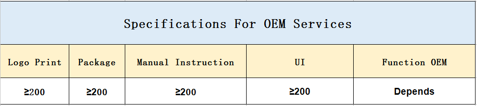
also welcome products OEM orders, logo print,package or manual
instruction customization etc. Whether selecting a current product
from our catalog or seeking engineering assistance for your
application, you can talk freely to our customer service center
about your sourcing requirements. Besides, we are making great
efforts to develop new products to meet different requirements. Our
company has quality control equipment to strictly control the
product quality. Adhering to the business principle of mutual
benefits, we have a good reputation among our customers because of
our perfect services, quality products and competitive prices. We
warmly welcome customers from at home and abroad to cooperate with
us for common success.