GNSS GLONASS Handheld GPS Survey Devices Machine Load Area
Measurement
Technology parameter:
| Receiver chip | High sensitivity GPS receiver chip |
| Receiver antenna | Passive large-size planar antenna |
| Efficient startup | 1sec for warm boot, 30sec for cold boot. |
| Area accuracy | Measurement error within 0.03Mu(1-3Mu),2%(above 3Mu) |
| Distance accuracy | Within 1m(HDOP less than 1.0,measuring 100m in length) |
| Function characteristics | Longitude and latitude display,altitude display,area
measurement,distance measurement,land price calculation |
| Data statistics | Area statistics,distance statistics |
| Area record | 99pieces |
| Distance record | 99pieces |
| Track display | The track will be displayed in real time in the course of
measurement,it can also be viewed in statistical records. |
| Barometric leveling | About 1meter(Barometric measurement,the absolute altitude value
needs to be calibrated) About 10 meters(GPS measurement ,HDOP within 1.0) |
| HDOP setting | Custom HDOP setting |
| Screen display | 2.4 inch outdoor HD black-white |
| Prompt tone | Voice broadcast |
| Working temperature | -20°C~65°C |
| Storage temperature | -40°C~75°C |
| Equipment size | 117mm×61mm×22mm |
| Equipment weight | 120g(No battery) |
| Data interface | USB interface,it can be charged through this interface |
| Standard configuration | Host 1,lithium battery 1,charger 1,data line 1,lanyard
1,instruction 1,warranty card 1,packaging box 1. |
Function Specification:
1. Normal Area Measurement
2. Fixed Width Area Measurement
3. Machine Load Area Measurement
4. Slope Area Measurement
5. Intell.Slope Measurement
6. Fixed Point Measurement
7. L/W Area Measurement
8. Mountain Area Measurement
9. Normal Distance Measurement
10. Multipoint Distance Measurement
11. Slope Distance Measurement
12. Altitude Display
13. Altitude Measurement
14. Track Display
15. Real-time Track
16. Mu Setting
17. Unit Setting
18. Time Display
19. Data Statistics
20. Historical Record
21. Data Export
22. Car Charger
23. Lighting/Currency Detection
24. Voice Broadcast
25. Protection Level:IP66
Matters need attention:
①This product is high precision equipment,Please do not open it
privately,otherwise it will be deemed a waiver of our after-sales
service.
②This product powered by lithium batteries,do not put it under the
sun exposure. For other lithium battery transportation and
safety,please refer to relevant national regulations.
③When this product is not used for a long time,please take out the
battery.
④Please turn on the product and use it in open area,the effect is
the best.
⑤Affected by GPS signal,different regions receive different GPS
signals,the measurement results will be inconsistent,this is normal
condition,please feel free to use it.
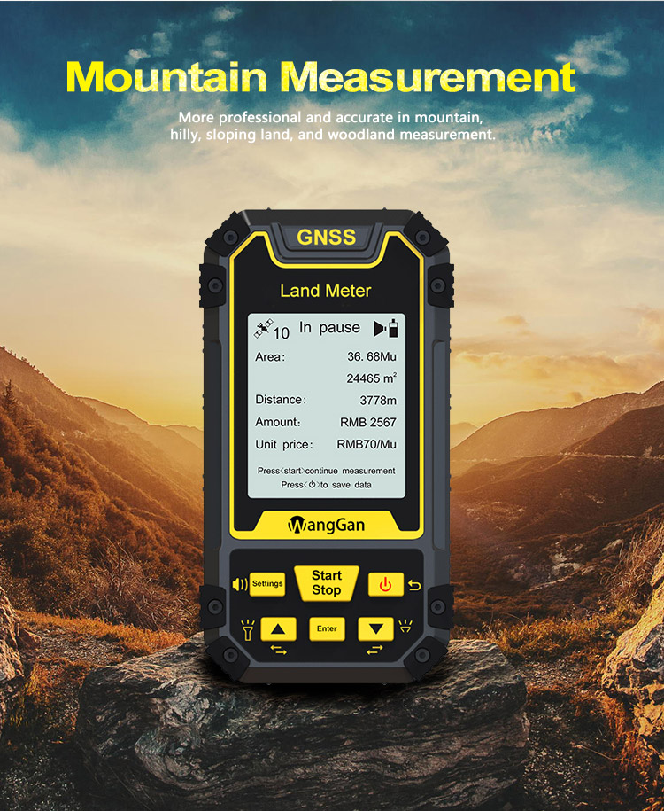
Mountain area measurement:
①In the main interface,press the ▲▼to switching function to
“Mountain”.
②Press the 【Start】button to measure at the top of the mountain,and
press the 【Enter】 button to confirm the information.
③Press the【Enter】button and proceed from the foot of the
mountain,walk around the foot of the mountain,and back to the
starting point,
press the【Enter】button,then press the【Stop】button to end measure
and view data;
④press "power" button to save the data.
In the measurement interface,three letters A,B and C will be
displayed next to "Mountain" above the screen.
A represents the location information of the mountain top
collected.
B represents the starting point at the foot of the mountain.
C represents to go around the foot of the mountain from the
starting point and then back to the starting point.