High Accuracy Handheld GPS Mountain Slope Flat Area Distance GPS
Land Measuring Instrument
GPS Machine Interface Display:
Product Parameters Of GPS Land Measuring Instrument:
| Receiver chip | High sensitivity GNSS receiver chip |
| Receiver antenna | Passive large-size planar antenna |
| Efficient startup | 1sec for warm boot, 30sec for cold boot. |
| Area accuracy | Measurement error within 0.03Mu(1-3Mu),2%(above 3Mu) |
| Distance accuracy | Within 1m(HDOP less than 1.0,measuring 100m in length) |
| Function characteristics | Longitude and latitude display,altitude display,area
measurement,distance measurement,land price calculation |
| Data statistics | Area statistics,distance statistics |
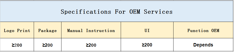
| Area record | 200pieces |
| Distance record | 200pieces |
| Track display | The track will be displayed in real time in the course of
measurement,it can also be viewed in statistical records. |
| Barometric leveling | About 1meter(Barometric measurement,the absolute altitude value
needs to be calibrated) About 10meters(GPS measurement ,HDOP within 1.0) |
| HDOP setting | Custom HDOP setting |
| Screen display | Color screen(320*240) |
| Prompt tone | Voice broadcast |
| Working temperature | -20℃~65℃ |
| Storage temperature | -40℃~75℃ |
| Equipment size | 117mm×61mm×20mm |
| Equipment weight | 120g(No battery) |
| Data interface | USB interface,it can be charged through this interface |
| Standard configuration | Host 1,lithium battery 1,charger 1,data line 1,lanyard
1,instruction 1,warranty card 1,packaging box 1. |

Product Function Introduction Of GPS Land Measuring Instrument:
Model
Functions | S3 | S4 |
| Positioning accuracy | 2.5m | 2.5m |
| Initial barometric calibration | × | √ |
| Normal area measurement | √ | √ |
| Mountain area measurement | × | √ |
| Intell. Slope measurement | × | √ |
| Fixed point measurement | √ | √ |
| Fixed width area measurement | √ | √ |
| Normal distance measurement | √ | √ |
| Manual distance measurement | √ | √ |
| Altitude display | √ | √ |
| Altitude measurement | √ | √ |
| Track display | √ | √ |
| Mu setting | √ | √ |
| Unit setting | √ | √ |
| Time display | √ | √ |
| Data statistics | √ | √ |
| Historical record | √ | √ |
| Lighting /Currency detection | √ | √ |
| Dry battery | √ | √ |
| lithium battery | √ | √ |
| Data storage | 200 | 200 |
| Voice broadcast | √ | √ |
| Data export | × | √ |
Built in barometer of this S4 land meter instrument, accurate to
measure altitude. There is intelligent mountain area measurement
mode in this
device. The combination of barometer and GPS dual satellite
positioning makes the measurement of mountain area more accurate
and easy.
Mountain Measurement
1. In the main interface,press the [▲/▼] to switch function to
“Mountain".
2. Press the [ Start] button to measure at the top of the mountain,
and press the [Enter] button to confirm the information.
3. Press the [Enter] button and proceed from the foot of the
mountain, walk around the foot of the mountain,and back to the
starting point,press
the [Enter] button,then press the [Stop] button to end measure and
view data.
4. Press "power" button to save the data.
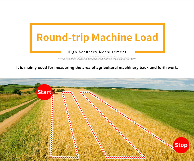
Round-trip machine load
. At the Round-trip machine load in parameter setting,press the
[▲/▼]button to set the width.
. After setting is completed,press the to return main interface.
. Press the [▲/▼]button switch function to Round-trip machine
load"in the main interface.
. Press [Start] button at the starting point to start the
measurement at the beginning of the work.Press the [Stop] button to
pause measurement
and view data after agricultural machinery work is completed;If the
measurement is not completed,press the [Start] button again to
continue the
measurement. If the measurement is completed,press "power" button
to save the data.
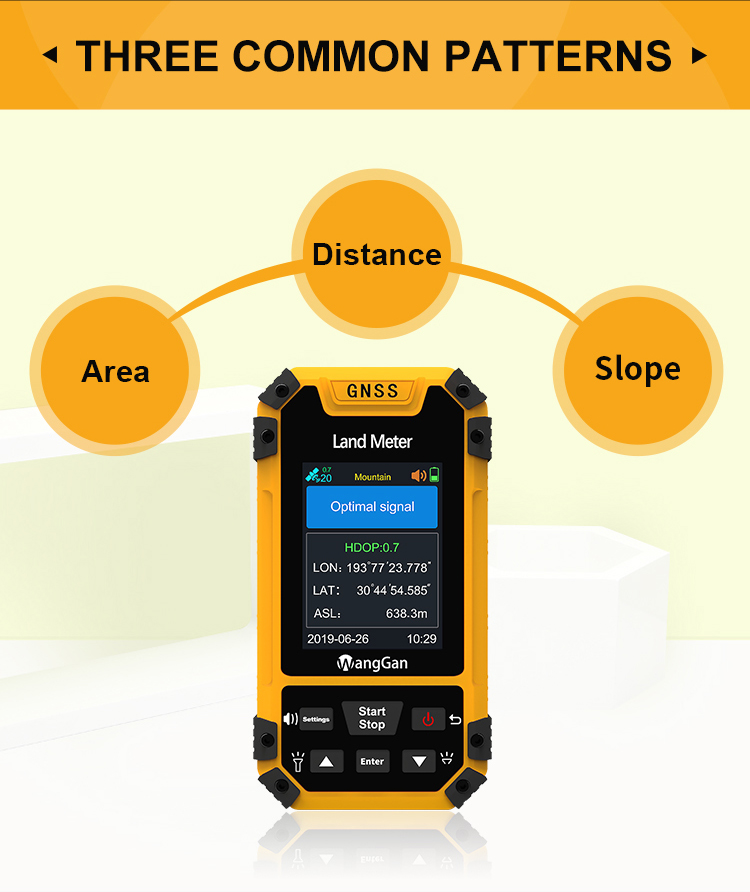
Intell Slope : at the starting point, press [Start/Stop] button to
measure in the main surface; walk around the slope and press the
[Start/Stop] button when you finished. Press the [Start/Stop] button to pause
the measurement. Press the "power" button to end measurement and
save data.
L/W mode : at the starting point , press the [Start/Stop] button to
measure,and press the [enter] button to save information; Going
from point to another point, press the [enter] button to save information; then
going from this point to the finial point, press the [enter] button
to save information; at last, press the [Start/Stop] button to view the
measurement data; press the "power" button to end measurement and
save data.
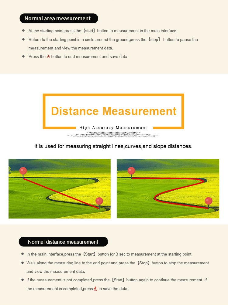
Normal distance mode: at the starting point, press [Start/Stop]
button to start measuring ;Walk along the measuring line to the
end point and press the [Stop] button to stop the measurement and view the measurement
data;If the measurement is not
completed,press the[Start]button again to continue the measurement. If the measurement is completed,press
"power" button
to save the data.
Normal mode : at the starting point, press [Start/Stop] button to
measure in the main surface; return to the starting point in a
circle around the ground, press the [Start/Stop] button to pause the measurement
data. Press the "power" button to end
measurement and save data.
Shutdown:
Press the button for about 2 secs and the shutdown page appears,
press the [enter] button to confirm the shutdown.


| Functions | S4 |
| Positioning accuracy | 2.5m |
| Initial barometric calibration | √ |
| Normal area measurement | √ |
| Mountain area measurement | √ |
| Intell. Slope measurement | √ |
| Fixed point measurement | √ |
| Fixed width area measurement | √ |
| Normal distance measurement | √ |
| Manual distance measurement | √ |
| Altitude display | √ |
| Altitude measurement | √ |
| Track display | √ |
| Mu setting | √ |
| Unit setting | √ |
| Time display | √ |
| Data statistics | √ |
| Historical record | √ |
| Lighting /Currency detection | √ |
| Dry battery | √ |
| lithium battery | √ |
| Data storage | 200 |
| Voice broadcast | √ |
| Data export | √ |


