Sign In | Join Free | My himfr.com
Home > GNSS GPS Survey Equipment >

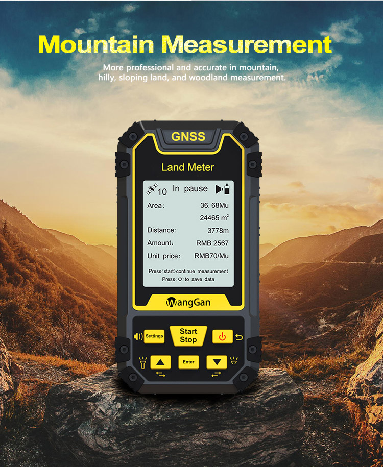
High Sensitivity GNSS GPS Survey Equipment For Land Area Distance Surveying

    Buy cheap High Sensitivity GNSS GPS Survey Equipment For Land Area Distance Surveying from wholesalers
     
    Buy cheap High Sensitivity GNSS GPS Survey Equipment For Land Area Distance Surveying from wholesalers
    • Buy cheap High Sensitivity GNSS GPS Survey Equipment For Land Area Distance Surveying from wholesalers
    • Buy cheap High Sensitivity GNSS GPS Survey Equipment For Land Area Distance Surveying from wholesalers
    • Buy cheap High Sensitivity GNSS GPS Survey Equipment For Land Area Distance Surveying from wholesalers
    • Buy cheap High Sensitivity GNSS GPS Survey Equipment For Land Area Distance Surveying from wholesalers
    • Buy cheap High Sensitivity GNSS GPS Survey Equipment For Land Area Distance Surveying from wholesalers
    • Buy cheap High Sensitivity GNSS GPS Survey Equipment For Land Area Distance Surveying from wholesalers

    High Sensitivity GNSS GPS Survey Equipment For Land Area Distance Surveying

    Ask Lasest Price
    Brand Name : Wanggan
    Model Number : S2
    Certification : ISO9001
    Price : $70-$80
    Payment Terms : T/T, Western Union, MoneyGram
    Supply Ability : 10000 sets/month
    Delivery Time : 10 working days
    • Product Details
    • Company Profile

    High Sensitivity GNSS GPS Survey Equipment For Land Area Distance Surveying

    GNSS GPS Survey Equipment Land Surveying Instrument GPS Land Meter Measuring Land Area Distance Tools


    Slope Measurement:


    . At the Slope in parameter setting, press the [▲/▼] button to set the gradient.


    . After setting is completed,press the d to return main interface.


    .In the main interface,press the [▲/▼] button to switch function to "Slope measurement".


    .Press the [ Start] button at the staring point and circle the slope.


    . Back to the starting point, press the I Stop ] button to pause measurement and view data.If the measurement is not completed, press the [ Start]


    button again to continue the measurement.


    .If the measurement is completed, press "power" button to save the data


    Technology Parameter Of Handheld GPS Survey Equipment:


    Receiver chipHigh sensitivity GPS receiver chip
    Receiver antenna

    Taimeng passive large-size planar antenna

    Efficient startup1sec for warm boot, 30sec for cold boot.
    Area accuracyMeasurement error within 0.03Mu(1-3Mu),2%(above 3Mu)
    Distance accuracy

    Within 1m(HDOP less than 1.0,measuring 100m in length)

    Function characteristics

    Longitude and latitude display,altitude display,area measurement,distance measurement,land price calculation

    Data statistics

    Area statistics,distance statistics

    Area record99pieces
    Distance record99pieces
    Track display

    The track will be displayed in real time in the course of measurement,it can also be viewed in statistical records.

    Barometric leveling

    About 1meter(Barometric measurement,the absolute altitude value needs to be calibrated)

    About 10meters(GPS measurement ,HDOP within 1.0)

    HDOP settingCustom HDOP setting
    Screen display

    2.4 inch outdoor HD black-white screen

    Prompt toneVoice broadcast
    Working temperature-20°C~65°C
    Storage temperature-40°C~75°C
    Equipment size117mm×61mm×22mm
    Equipment weight

    120g(No battery)

    Data interface

    USB interface,it can be charged through this interface

    Standard configuration

    Host 1,lithium battery 1,charger 1,data line 1,lanyard 1,instruction 1,warranty card 1,packaging box 1.


    Quality High Sensitivity GNSS GPS Survey Equipment For Land Area Distance Surveying for sale
    Inquiry Cart 0
    Send your message to this supplier
     
    *From:
    *To: Chengdu Wanggan Technology Co., Ltd.
    *Subject:
    *Message:
    Characters Remaining: (0/3000)